The DOQ index represents an index for the Digital Orthophoto Quadrangles (DOQ) of Oregon, resources made available by the hard work at the Oregon Geospatial Enterprise Office. So what is a DOQ? Well, DOQ is a uniform-scaled image that can be measured or used like any other map. This is different from a regular aerial photograph, in that most aerial photographs do not have a uniform scale, because conditions like image distortions caused by the tilting of the camera or geographic terrain. These distortions make it impossible to measure distances on an aerial photograph like one can on a map. As such, DOQs provide researchers with a photographic map, which can be used and combined with other information resources.
For more information, please see:
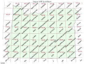
The location indicator is a clickable map of Oregon, which provides lists of the quadrangles within each area.